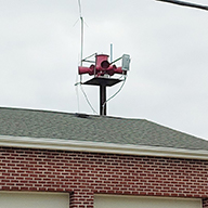
Found another siren that's not on the map. A STL-10 that is part of Steelville's siren network. According to https://www.meramecregion.org/wp-conten ... -Small.pdf the city of steelville has six sirens, and including the STL-10, there are 4 that we know of. A pic I took of it is at - https://ibb.co/4p1N9qM
The STL-10 is located at
37°58'31.85"N
91°21'28.47"W
-
railroader3921
- Posts: 34
- Joined: Wed Dec 14, 2016 6:34 pm
- YouTube Username: Railroader3921
- Location: St. Louis, MO
- Contact: YouTube
Re: The official and updated Missouri Statewide map
One of Indianola, Iowa's old RM-127's is currently sitting in my backyard.
-
jacob585
- Registered User

- Posts: 668
- Joined: Mon Jun 26, 2017 5:43 pm
- Real Name: Jacob Ulrich
- YouTube Username: SouthMissouriSirens
- Discord: MidMissouriSirens#9512
- Location: Marshfield Missouri
- Contact: Twitter YouTube
Re: The official and updated Missouri Statewide map
Thank you for the location!railroader3921 wrote: ↑Wed Oct 07, 2020 9:51 pmFound another siren that's not on the map. A STL-10 that is part of Steelville's siren network. According to https://www.meramecregion.org/wp-conten ... -Small.pdf the city of steelville has six sirens, and including the STL-10, there are 4 that we know of. A pic I took of it is at - https://ibb.co/4p1N9qM
The STL-10 is located at
37°58'31.85"N
91°21'28.47"W
I'm Jacob Ulrich or MidMissouriSirens on youtube.
My Missouri Siren Map: https://www.google.com/maps/d/u/0/edit? ... 57595&z=10
My Missouri Siren Map: https://www.google.com/maps/d/u/0/edit? ... 57595&z=10
-
jacob585
- Registered User
- Posts: 668
- Joined: Mon Jun 26, 2017 5:43 pm
- Real Name: Jacob Ulrich
- YouTube Username: SouthMissouriSirens
- Discord: MidMissouriSirens#9512
- Location: Marshfield Missouri
- Contact: Twitter YouTube
Re: The official and updated Missouri Statewide map
10/22/2020 Changelog
-More Arkansas Locations Added
-Viburnum Missouri Vortex added
-5th siren in Steelville added
-Eminence and Birch Tree Locations added
-More Arkansas Locations Added
-Viburnum Missouri Vortex added
-5th siren in Steelville added
-Eminence and Birch Tree Locations added
I'm Jacob Ulrich or MidMissouriSirens on youtube.
My Missouri Siren Map: https://www.google.com/maps/d/u/0/edit? ... 57595&z=10
My Missouri Siren Map: https://www.google.com/maps/d/u/0/edit? ... 57595&z=10
-
archizackture
- Registered User
- Posts: 332
- Joined: Fri May 03, 2019 2:52 pm
- YouTube Username: Shako_Lamb
- Location: Burlington, VT & Berkeley Springs, WV
- Contact: Twitter YouTube
Re: The official and updated Missouri Statewide map
The map is looking absolutely fantastic, but I just want to point out that caution should be used with the word "official." In this context, "official" would indicate that the map was approved or created by a state agency. This map may be by far the most comprehensive that any enthusiast has made, but that doesn't mean it has the authoritative backing that the word "official" implies. Unless you were, in fact, commissioned by a state agency to create it and I just didn't know that.
Architecture preservationist. I enjoy obscure history and mapping things, and grew up around sirens. Not planning to own one.
West Virginia State-wide & Western Maryland Siren Map
West Virginia State-wide & Western Maryland Siren Map
-
jacob585
- Registered User
- Posts: 668
- Joined: Mon Jun 26, 2017 5:43 pm
- Real Name: Jacob Ulrich
- YouTube Username: SouthMissouriSirens
- Discord: MidMissouriSirens#9512
- Location: Marshfield Missouri
- Contact: Twitter YouTube
Re: The official and updated Missouri Statewide map
I put official in it because this is basically the replacement for any other Missouri siren maps. Its the "Official" statewide map because its the most accurate and up to date.archizackture wrote: ↑Fri Oct 23, 2020 2:37 amThe map is looking absolutely fantastic, but I just want to point out that caution should be used with the word "official." In this context, "official" would indicate that the map was approved or created by a state agency. This map may be by far the most comprehensive that any enthusiast has made, but that doesn't mean it has the authoritative backing that the word "official" implies. Unless you were, in fact, commissioned by a state agency to create it and I just didn't know that.
I'm Jacob Ulrich or MidMissouriSirens on youtube.
My Missouri Siren Map: https://www.google.com/maps/d/u/0/edit? ... 57595&z=10
My Missouri Siren Map: https://www.google.com/maps/d/u/0/edit? ... 57595&z=10
-
archizackture
- Registered User
- Posts: 332
- Joined: Fri May 03, 2019 2:52 pm
- YouTube Username: Shako_Lamb
- Location: Burlington, VT & Berkeley Springs, WV
- Contact: Twitter YouTube
Re: The official and updated Missouri Statewide map
I totally understand that, and I know that's how the word "official" is commonly used. But that's in fact a common misuse of the word, because the actual, formal, specific meaning of "official" is that it has been endorsed or otherwise created by a relevant authority. Based on the title saying that it's an "official" "statewide" map, it would be logical for someone to assume that this map was published by the State of Missouri, and I would hope that you don't run into trouble from someone who thinks you're posing as the state government. Slim chance, but you never know and for your own protection it's best to consider formalities when choosing titles for things.jacob585 wrote: ↑Fri Oct 23, 2020 11:48 pmI put official in it because this is basically the replacement for any other Missouri siren maps. Its the "Official" statewide map because its the most accurate and up to date.archizackture wrote: ↑Fri Oct 23, 2020 2:37 amThe map is looking absolutely fantastic, but I just want to point out that caution should be used with the word "official." In this context, "official" would indicate that the map was approved or created by a state agency. This map may be by far the most comprehensive that any enthusiast has made, but that doesn't mean it has the authoritative backing that the word "official" implies. Unless you were, in fact, commissioned by a state agency to create it and I just didn't know that.
Architecture preservationist. I enjoy obscure history and mapping things, and grew up around sirens. Not planning to own one.
West Virginia State-wide & Western Maryland Siren Map
West Virginia State-wide & Western Maryland Siren Map
-
jacob585
- Registered User
- Posts: 668
- Joined: Mon Jun 26, 2017 5:43 pm
- Real Name: Jacob Ulrich
- YouTube Username: SouthMissouriSirens
- Discord: MidMissouriSirens#9512
- Location: Marshfield Missouri
- Contact: Twitter YouTube
Re: The Official And Updated Missouri Statewide Map
Changelog 10/25/2020
-Remaining Northern Arkansas Border Counties added
-Remaining Northern Arkansas Border Counties added
I'm Jacob Ulrich or MidMissouriSirens on youtube.
My Missouri Siren Map: https://www.google.com/maps/d/u/0/edit? ... 57595&z=10
My Missouri Siren Map: https://www.google.com/maps/d/u/0/edit? ... 57595&z=10
-
SirensOfNewYork
- Registered User
- Posts: 489
- Joined: Sat Nov 23, 2019 7:24 pm
- Location: New York, of course
Re: The official and updated Missouri Statewide map
Are there even officially official (if you know what I mean) siren maps? Like issued to the EMA?archizackture wrote: ↑Sat Oct 24, 2020 4:54 amI totally understand that, and I know that's how the word "official" is commonly used. But that's in fact a common misuse of the word, because the actual, formal, specific meaning of "official" is that it has been endorsed or otherwise created by a relevant authority. Based on the title saying that it's an "official" "statewide" map, it would be logical for someone to assume that this map was published by the State of Missouri, and I would hope that you don't run into trouble from someone who thinks you're posing as the state government. Slim chance, but you never know and for your own protection it's best to consider formalities when choosing titles for things.jacob585 wrote: ↑Fri Oct 23, 2020 11:48 pmI put official in it because this is basically the replacement for any other Missouri siren maps. Its the "Official" statewide map because its the most accurate and up to date.archizackture wrote: ↑Fri Oct 23, 2020 2:37 amThe map is looking absolutely fantastic, but I just want to point out that caution should be used with the word "official." In this context, "official" would indicate that the map was approved or created by a state agency. This map may be by far the most comprehensive that any enthusiast has made, but that doesn't mean it has the authoritative backing that the word "official" implies. Unless you were, in fact, commissioned by a state agency to create it and I just didn't know that.
~SirensOfNewYork
Amateur HVAC, Siren, Car, Plane, and security and fire alarm enthusiast
My profile photo is not mine. It belongs to the creator of the California siren map.
Amateur HVAC, Siren, Car, Plane, and security and fire alarm enthusiast
My profile photo is not mine. It belongs to the creator of the California siren map.
-
uncommonsense
Re: The official and updated Missouri Statewide map
Or made by EMAs? Absolutely.SirensOfNewYork wrote: ↑Mon Oct 26, 2020 12:17 pmAre there even officially official (if you know what I mean) siren maps? Like issued to the EMA?
-
Jared H

- Registered User
- Posts: 432
- Joined: Sat Dec 05, 2009 11:04 pm
- YouTube Username: The Siren Seekers
- Discord: shodowhater#1003
- Location: Dallas TX
Re: The official and updated Missouri Statewide map
Missing a T-Bolt at 36.65089, -93.508
------------------------------
Apparently the chat room is haunted... -VASirens 2015
Friendly Neighborhood Thunderboltologist, if such a thing exists.
Apparently the chat room is haunted... -VASirens 2015
Friendly Neighborhood Thunderboltologist, if such a thing exists.
Who is online
Users browsing this forum: No registered users and 0 guests