The Darley in Crescent was replaced with a shiny yellow 2T22, heard it 26 minutes ago haha, the Screamer is still standing.
Another note, the champion in Thomas is sadly gone, probably was destroyed as the building is gone too, now a family dollar stands in the place of the old building.
-
Valra Bellkeys
- Registered User

- Posts: 862
- Joined: Sun Aug 23, 2015 6:55 am
- Real Name: Carson
- YouTube Username: Valra Bellkeys
- Discord: Valra Bellkeys#0164
- Location: Oklahoma
- Contact: YouTube
Re: Finally releasing to the public...Oklahoma Statewide Map
I own: One complete SiraTone, another SiraTone control module, a 1600W MC, 2 old ATI controllers, 2 round ATI horns with drivers, a ATI-DSA 4 thing, a Federal Signal FC, AR timer and Siratrol, and a small CD&F.
-
Brendan W

- Supporter

- Posts: 2307
- Joined: Fri Apr 08, 2011 12:51 am
- Real Name: Brendan Williamson
- YouTube Username: Brendan Williamson
- Discord: Brendan W.#7026
- Location: Gwinnett County, GA
- Contact: Website Facebook Skype Twitter YouTube
Re: Finally releasing to the public...Oklahoma Statewide Map
Got two for you in Grant:
Manchester has a Darley and a Model D. Former is at the FD, Latter is on a building across Main from the FD.
Manchester has a Darley and a Model D. Former is at the FD, Latter is on a building across Main from the FD.
24, and not dead yet.
Registered Skywarn spotter as of 4/29/18
Formerly TboltFan[/i]
Registered Skywarn spotter as of 4/29/18
Formerly TboltFan[/i]
-
Synther
- Global Moderator

- Posts: 1056
- Joined: Fri Jul 10, 2015 5:57 am
- YouTube Username: UtahSirens
- Location: Utah
- Contact: YouTube
Re: Finally releasing to the public...Oklahoma Statewide Map
Unrelated, but why did the map get deleted?
-
Purring Cat
- Registered User
- Posts: 301
- Joined: Fri Apr 20, 2018 5:01 pm
- Real Name: Jon Neal
- YouTube Username: Purring Cat
- Location: Kentucky, USA
Re: Finally releasing to the public...Oklahoma Statewide Map
I don't know why.
-
CarterMasterAlt

- Registered User
- Posts: 57
- Joined: Tue Mar 21, 2023 1:07 am
- Real Name: Kevin Ledesma
- YouTube Username: Sirens of Bexar County
- Discord: sirensofbexarcounty
- Location: San Antonio, Bexar County, Texas
Re: Finally releasing to the public...Oklahoma Statewide Map
Im not sure if you know, but the link doesn't work anymore. This is either removed or the link is outdateddilloncarpenter wrote: ↑Wed May 18, 2016 1:27 amAfter over four years of steady work on this, I think I finally have enough of this completed for me to release it into the general public. This is created in Google Earth, using folders to organize sirens into cities and counties, making it an easy map to navigate instead of having 1000+ placemarks just in one list. I'm pretty sure you can view it with Google maps, but I would recommend downloading it to Earth for easier use. I have had many people contribute and help with locations and those individuals I made sure to list in the description. Overall, I'd say it's about 95% complete as of this writing. Off the top of my head, towns or cities I know are not complete are McAlester, Tulsa, Bartlesville, Hominy, Pawhuska, Vinita, Clinton, Frederick, Duncan, Durant, Sand Springs, Sallisaw, Muskogee, and Poteau. If I happen to know the testing schedule of certain areas, they are listed in the description of those areas.
Anyways, without further ado, follow the link to take you to the Oklahoma Statewide Siren Map.
https://drive.google.com/open?id=0Bz8Yn ... 2RGWXZ6RkU
This is a block of text that can be added to posts you make. There is a 255 character limit.
-
shodowhater
- Registered User
- Posts: 124
- Joined: Thu Jan 22, 2015 1:11 am
- Real Name: Jared Harrell
Re: Finally releasing to the public...Oklahoma Statewide Map
It's here now. The color scheme was changed and different people work on it, but the base map is the KML file linked above that no longer works.CarterMasterAlt wrote: ↑Thu Sep 07, 2023 10:54 pmIm not sure if you know, but the link doesn't work anymore. This is either removed or the link is outdated
https://www.google.com/maps/d/u/0/viewe ... 75785&z=17
"Y'know what would suck? Driving a river." - Jeremy Munyon, 2019
-
gabetlamb
- Registered User
- Posts: 133
- Joined: Mon Feb 25, 2019 9:05 pm
- Real Name: Gabriel Lamb
- YouTube Username: Gabriel Lamb
- Location: Watertown NY
- Contact: Twitter
Re: Finally releasing to the public...Oklahoma Statewide Map
There's already a map of Oklahoma with two versions Icon or Color Code
-
md5

- Registered User
- Posts: 1112
- Joined: Mon Sep 10, 2007 10:39 am
- Real Name: Brett
- YouTube Username: bctrainers
- Location: Olathe, KS
- Contact: Website
Re: Finally releasing to the public...Oklahoma Statewide Map
Hi folks, I recently watched a tornado damage/aftermath drone video and noticed something: a Thunderbolt 1000T was downed.
What's intriguing is that most of the siren appears to be intact, but the age of the 1000T suggests it will probably end up as scrap. Is anyone down there able to contact the city to see what they'll be doing with it?
https://www.youtube.com/watch?v=eBFBMnkXS6o
What's intriguing is that most of the siren appears to be intact, but the age of the 1000T suggests it will probably end up as scrap. Is anyone down there able to contact the city to see what they'll be doing with it?
https://www.youtube.com/watch?v=eBFBMnkXS6o
- brave_2024-05-11_06-37_5190e348-5ae2-4b65-bdb4-e9a5f9f5ab2f.png (4.33 MiB) Viewed 223 times
--bc
-
traintraveler
- Registered User
- Posts: 276
- Joined: Fri Dec 23, 2022 11:25 pm
- Real Name: Cody P
- YouTube Username: Train Traveler
- Location: Hall County, GA
Re: Finally releasing to the public...Oklahoma Statewide Map
The Thunderbolt has been confirmed to have gone into the hands of Goddard Enterprises. It's safe, at least for now.md5 wrote: ↑Sat May 11, 2024 11:38 amHi folks, I recently watched a tornado damage/aftermath drone video and noticed something: a Thunderbolt 1000T was downed.
What's intriguing is that most of the siren appears to be intact, but the age of the 1000T suggests it will probably end up as scrap. Is anyone down there able to contact the city to see what they'll be doing with it?
https://www.youtube.com/watch?v=eBFBMnkXS6o
brave_2024-05-11_06-37_5190e348-5ae2-4b65-bdb4-e9a5f9f5ab2f.png
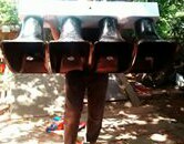
Here's some close-up pictures.
- 440576783_10224520229696113_6904385813139644984_n.jpg (716.52 KiB) Viewed 196 times
- 441711427_10224520230976145_3280567839181884010_n.jpg (860.72 KiB) Viewed 196 times
- 441454212_10224520230816141_2339148391320026324_n.jpg (905.06 KiB) Viewed 196 times
High Hoods!
Lord knows I can't change
Lord, help me, I can't change
Lord, I can't change
Won't you fly high, free bird, yeah
Lord knows I can't change
Lord, help me, I can't change
Lord, I can't change
Won't you fly high, free bird, yeah
Who is online
Users browsing this forum: No registered users and 5 guests