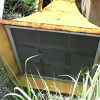
When I was working on my U.S. Siren Map, I was marking an old Federal Sign & Signal 500 in Los Angeles. I couldn't see it on arial view, so I went to street view. I dropped next to the siren and it was facing NW. I went to the intersection and saw it was facing West. I looked at the wires and they weren't cut like the rest of them. Can anyone helpp me? I'm confused. Thanks!
This is what I saw first: https://earth.google.com/web/@34.228143 ... NBSF94dxAC
Then what I saw at the intersection: https://earth.google.com/web/@34.228313 ... RZYWRwZxAC
You can clearly see that it changed directions!
-
Someone22
- Registered User

- Posts: 129
- Joined: Fri Dec 16, 2016 1:04 am
- Real Name: Mike
- Location: New Jersey
Re: Possible Old L.A. Siren still in use?
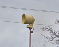
The belts on a lot of these either lost tension or broke, I don't think any of the old CD era sirens are still used.
-
coastalsyrolover

- Registered User
- Posts: 1777
- Joined: Thu Feb 27, 2014 10:01 pm
- Real Name: Christian Long
- Location: Wonderful Western Oregon.
Re: Possible Old L.A. Siren still in use?
Considering how tight Cali can be with some of their laws it would surprise me if they did.
Own and love a Thunderbolt 1000 and a Model 5.
I have many hobbies and interests. And I love them all.
Christian, Lima, Oscah, November, Golf.
I have many hobbies and interests. And I love them all.
Christian, Lima, Oscah, November, Golf.
-
Tyler
- Developer

- Posts: 1376
- Joined: Mon May 06, 2013 1:51 am
- Real Name: Tyler Brasher
- YouTube Username: Thunderbolt10031
- Contact: Skype YouTube
Re: Possible Old L.A. Siren still in use?
All of the sirens in that particular system are not in use and haven't been in decades. This is also a Federal 500 siren, which is notorious for belts loosing tension/breaking, then waving in the wind.
My knowledge excels on the Federal Thunderbolt siren and SiraTone EOWS sirens. ¯\_(ツ)_/¯
Proud owner of
2014 Federal UltraVoice UVICU
1981 SiraTone C/B prototype
1984 SiraTone C/B
Proud owner of
2014 Federal UltraVoice UVICU
1981 SiraTone C/B prototype
1984 SiraTone C/B
-
Trashbeam
- Registered User
- Posts: 149
- Joined: Sun Mar 04, 2018 2:25 pm
- Real Name: Cameron Keske
- YouTube Username: Sirens of NE Ohio
Re: Possible Old L.A. Siren still in use?
Thanks for all the help. That make a lot more sence now with the belts.
-
Synther
- Global Moderator

- Posts: 1054
- Joined: Fri Jul 10, 2015 5:57 am
- YouTube Username: UtahSirens
- Location: Utah
- Contact: YouTube
Re: Possible Old L.A. Siren still in use?
There are a few videos of them moving in the wind.
-
Hacksaw
- Registered User
- Posts: 1279
- Joined: Wed May 17, 2006 11:38 pm
- Real Name: Mike H
- Location: San Jose, CA
Re: Possible Old L.A. Siren still in use?
They pulled the plug on those sirens around 1983. Yes, the rotator system on those seemed to be very troublesome.
-
Connorman959
- New User
- Posts: 4
- Joined: Thu May 27, 2021 5:08 am
- Real Name: connor
- YouTube Username: Connor's computer stuff & more
- Location: Texas
Re: Possible Old L.A. Siren still in use?
I assume the same thing happened to the the one on Hillrose street, moved before January 2021.
-
Model L

- Global Moderator
- Posts: 623
- Joined: Wed Dec 28, 2016 4:19 am
- YouTube Username: Egress
- Discord: Egress.
- Location: Beaverton, Oregon
Re: Possible Old L.A. Siren still in use?
Yes, likely the rotator belt has lost tension and or has broken and the siren is rotating with the wind.Connorman959 wrote: ↑Tue Jan 18, 2022 12:02 amI assume the same thing happened to the the one on Hillrose street, moved before January 2021.
Resident of Beaverton, Oregon
Proud owner of 2 Model L's and a 1984 WS-3000 serial # 717
19 years old
want to chat? send me a request on discord: Egress.#7444 or DM me
Proud owner of 2 Model L's and a 1984 WS-3000 serial # 717
19 years old
want to chat? send me a request on discord: Egress.#7444 or DM me
-
insertusernamehere94
- Registered User
- Posts: 58
- Joined: Tue Apr 10, 2018 3:30 am
- Real Name: Ryan
Re: Possible Old L.A. Siren still in use?
The ONLY LA siren still in use is a model 7T on Catalina Island. The town of Avalon uses it as a fire siren.
Return to “Main Outdoor Warning Sirens Board”
Who is online
Users browsing this forum: Google [Bot], Palmspringslocator2 and 43 guests