
I noticed the post on the old board and i got locations of the sirens and my gosh there are a lot of gaps...i have maps for 5 of the 9 zones in Marion County, i will get to the other zones tomorrow but here are the ones i have now
Zone1
Zone2
Zone3
Zone4
Zone5
-
quiksmith10

- Registered User

- Posts: 145
- Joined: Mon May 15, 2006 9:52 pm
- Location: SW of Gettysburg, PA
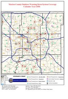
Well, actually, there is a more accurate depiction of the siren system from Marion County Emergency Management. The siren coverage you display don't seem to stretch far enough. The actual depiction of Indianapolis shows that almost all the sirens inside I-465 overlap with others, creating a great system of sirens with no coverage gaps. Here is the thread started on the old forum which will soon include the surrounding counties of Indianapolis (starting with Hamilton County I believe):
http://www.airraidsirens.com/board/view ... sc&start=0
A current map with added siren locations with a color key (courtesy of Matt Heckler - caution large file size):
http://img.photobucket.com/albums/v63/q ... n4_new.jpg
I have the actual PDF of the system before Marion County took it off their website during an upgrade. I'll go hunting through my data CD's to pull it up. Once I do, I'll post it.
Brandon Smith
-
Matt Hackler

- Registered User
- Posts: 268
- Joined: Mon May 15, 2006 3:19 pm
- Real Name: Matt Hackler
- YouTube Username: Matt Hackler
- Location: Greenwood, Indiana
Hamilton County,
Well this is the map that I've created. It was a hell of a lot of work, but it looks cool. Brandon has looked up most of the sites which have all been 2001's, and I've looked up some and they've all been 2001's. So I went ahead and put 2001's to the north, the ones with a black cross in the center. Those are the ones I'm not sure on because birdseye does not go that far. All of the others are confirmed 2001's. It's not completely done but I thought I'd go ahead and post it since Brandon mentioned it. You can also see some overlaps from Marion County to the South. Madison County is next on my list but it will take longer, no birdseye.
http://putfile.com/pic.php?pic=5/13716333791.jpg&s=f5
Matt,
http://putfile.com/pic.php?pic=5/13716333791.jpg&s=f5
Matt,
"The Federal Thunderbolt siren is a rotating-beam siren that disperses high-intensity warning signals over a large area." :TBolt:
-
Matt Hackler
- Registered User
- Posts: 268
- Joined: Mon May 15, 2006 3:19 pm
- Real Name: Matt Hackler
- YouTube Username: Matt Hackler
- Location: Greenwood, Indiana
New Sirens,
Well I know on the old board people stated once or twice what type of sirens Indianapolis should use. So that is the question, in you opinion what type do you think would be best for Indianapolis. I would give my nod to the Sentry Defender. It has a lower tone than the 2001 and can be heared better than the 2001 at a further distance. I also like the fact that it only has one motor. So what do all of you think? This is sort of just for fun, we all know that it's probably going to be Federal doing the job since they already have 69 2001's placed there. So go ahead and give an opinion,
"The Federal Thunderbolt siren is a rotating-beam siren that disperses high-intensity warning signals over a large area." :TBolt:
-
Matt Hackler
- Registered User
- Posts: 268
- Joined: Mon May 15, 2006 3:19 pm
- Real Name: Matt Hackler
- YouTube Username: Matt Hackler
- Location: Greenwood, Indiana
Just thought I would put up this information, on Monday the Indianapolis Purchasing Department will put out the Request for Proposals for the new siren system. When it goes up I'll put the address here so everyone can view it. My friend at MCEMA said that the city council has appropriated 7 million dollars for the new system. Doug thinks it's only gonna cost between 5 and 6 million. And he and I both still think that Federal will be doing the job, but they have to put it up for bid. So until Monday,
"The Federal Thunderbolt siren is a rotating-beam siren that disperses high-intensity warning signals over a large area." :TBolt:
-
Matt Hackler
- Registered User
- Posts: 268
- Joined: Mon May 15, 2006 3:19 pm
- Real Name: Matt Hackler
- YouTube Username: Matt Hackler
- Location: Greenwood, Indiana
Yeah since it will most likely be Federal they will be 2001's. All of the new sirens and the replacement sirens put up in the last decade have been 2001's. Actually 2001's are the majority of the siren system with 68 out of the 140 sirens being 2001's. They want a uniform system, and since they already have 2001's it just gives Federal one more edge over everyone else.
"The Federal Thunderbolt siren is a rotating-beam siren that disperses high-intensity warning signals over a large area." :TBolt:
-
Matt Hackler
- Registered User
- Posts: 268
- Joined: Mon May 15, 2006 3:19 pm
- Real Name: Matt Hackler
- YouTube Username: Matt Hackler
- Location: Greenwood, Indiana
Well It does not give much information, but the request is finally out there. Scroll down to the bottom of the page and you'll find it. I don't know if it's possible but the city wants the system up and ready for the next Tornado season. Well like I said it's down near the bottom of the screen.
http://www.indygov.org/eGov/City/Contro ... ds/opp.htm
http://www.indygov.org/eGov/City/Contro ... ds/opp.htm
"The Federal Thunderbolt siren is a rotating-beam siren that disperses high-intensity warning signals over a large area." :TBolt:
Return to “Main Outdoor Warning Sirens Board”
Who is online
Users browsing this forum: Amazon [Bot], Bing [Bot], JJ_OFU and 39 guests