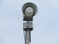

Due to the remote qualities of the region, as well as the roughness of the terrain (especially in the glacial lakes area), many of the sirens and other equipment were transported to their intended locations via yak and mule (which takes 9 days each way). The sirens were positioned high above key areas and populations centers to provide maximum sound dispersion. Each siren is mounted on a short metal pole along with a custom control cabinet, solar panel, and antenna, and each unit is enclosed in a small fence. The DC-only nature of these units allows them to exist far from roads, power lines, or other infrastructure.

Here is a photo of the inside of one of the control cabinets (paging Dennis Seldon).

The original intention was for the sirens to be radio activated, but it was deemed to expensive to set up repeater sites throughout the valley. Instead, the sirens are activated via Sutron's Iridium® Satellite Communications network. The flood control center often has varying internet connectivity, so they are also hooked into the satellite network in case of internet downtime.

As far as other instrument included in the flood warning system, 2 automatic weather stations, 4 automatic water level stations, 23 data loggers, and 6 constant flow bubblers were installed. A control building was also constructed, and a custom siren GUI was implemented. The sirens are activated when a user-set threshold value is reached. The populace within the flooding zone was trained on how to respond to the sirens.
I managed to find a few vague maps of the siren system, as well as a low quality screenshot of the siren GUI with what appear to be location descriptions, and with the help of a few others, managed to find seven of the seventeen sirens (yes, this region has some streetview). If you would like to try and find more, feel free to try your hand with the maps and screenshot below, however it is unlikely the three "high-altitude" sirens as well as the few north of Punakha will be found very easily, as aerial imagery is lackluster and Streetview is nonexistent in these areas.

Here is the map that I have compiled thus far. Keep in mind that some of these are difficult to view on Streetview.
One more thing that I would like to note: the three sirens covering the glacial lakes region are located upwards of 12,000 ft. above sea level, likely making them some of the highest mounted sirens in the world (if not the highest).
Resources:
http://www.sutron.com/documents/bhutan-glof.pdf
ftp://ftp.earthobservations.org/documen ... TATION.pdf
https://www.midstatecomm.com/whelenflood.htm
http://www.hydromet.gov.bt/downloadfile/ews2.pdf