I remember seeing this siren in person back in the late 90's growing up in Garland. It was near a creek that fed into Duck Creek.hewo wrote: ↑Tue Jul 16, 2024 7:19 pmCorrect. You can see it pretty well with 2001 Aerial.60l7I wrote: ↑Sun Jun 02, 2024 6:49 pmThe hurricane was located off of Lawrence drive and High Plateau drive. 32.954812810486914, -96.66849739944544Greenrid wrote: ↑Wed May 29, 2024 11:13 pmI've been searching up locations of ACA Hurricanes recently, and as I've been trying to find them on historical aerial views to try to find their exact locations, I can't find them.
I know this one is in Garland, TX somewhere near Fire station #3, but the fire station wasn't even built back when the Garland Hurricane was still up. was there another location before the new location was built in 2007? The 2001 aerial view of the area is actually very crisp, so I should be able to find it. The Hurricane map says it's behind the Upendo Baptist church, but the imagery doesn't actually show any Hurricanes. I even tried the civil defense museum website, and it did say that it was on the corner of Jupiter and Bobbie, but it isn't there either.
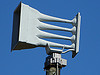
Also, does anyone know where this Hurricane was located? It seems like a dumb question, but I genuinely have no idea (please tell me this isn't the same exact Hurricane)
unnamed.jpg
Re: ACA Hurricane locations help
-
Greenrid

- Registered User

- Posts: 338
- Joined: Sat Oct 14, 2023 4:32 pm
- Real Name: G______
- Location: Lansing, MI
Re: ACA Hurricane locations help
I actually saw this a few weeks ago but I forgot to reply, but thanks for the location of one of the hurricanes! I'm still wondering about the first Hurricane I was talking about, though.60l7I wrote: ↑Sun Jun 02, 2024 6:49 pmThe hurricane was located off of Lawrence drive and High Plateau drive. 32.954812810486914, -96.66849739944544Greenrid wrote: ↑Wed May 29, 2024 11:13 pmI've been searching up locations of ACA Hurricanes recently, and as I've been trying to find them on historical aerial views to try to find their exact locations, I can't find them.
I know this one is in Garland, TX somewhere near Fire station #3, but the fire station wasn't even built back when the Garland Hurricane was still up. was there another location before the new location was built in 2007? The 2001 aerial view of the area is actually very crisp, so I should be able to find it. The Hurricane map says it's behind the Upendo Baptist church, but the imagery doesn't actually show any Hurricanes. I even tried the civil defense museum website, and it did say that it was on the corner of Jupiter and Bobbie, but it isn't there either.
Also, does anyone know where this Hurricane was located? It seems like a dumb question, but I genuinely have no idea (please tell me this isn't the same exact Hurricane)
unnamed.jpg
Proud owner of a E.A Labs Sireane Jr, a Uniden radio scanner, and a Sure-Lites emergency light!
Also the proud owner of the FULL 508 siren map! https://rb.gy/bgjrm1
I'm probably the go-to person to learn about my city's siren history.
Also the proud owner of the FULL 508 siren map! https://rb.gy/bgjrm1
I'm probably the go-to person to learn about my city's siren history.
Re: ACA Hurricane locations help
The Hurricane was at the old Fire Station #3 at Jupiter Rd. & Bobbie Ln. before the station moved down the street to Jupiter Rd. & O'Henry. The Hurricane had already been removed.
-
Greenrid
- Registered User
- Posts: 338
- Joined: Sat Oct 14, 2023 4:32 pm
- Real Name: G______
- Location: Lansing, MI
Re: ACA Hurricane locations help
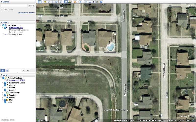
I've checked there when I first wanted to find the location. I took a screenshot of the aerial view in 2001, but I couldn't find it anywhere. The map says it's in the alley behind the Upendo Baptist Church, but I can't find it there either.
- Bobbie Ln. and Jupiter Rd. intersection
- Screenshot 2024-07-28 162334.png (3.22 MiB) Viewed 3102 times
Proud owner of a E.A Labs Sireane Jr, a Uniden radio scanner, and a Sure-Lites emergency light!
Also the proud owner of the FULL 508 siren map! https://rb.gy/bgjrm1
I'm probably the go-to person to learn about my city's siren history.
Also the proud owner of the FULL 508 siren map! https://rb.gy/bgjrm1
I'm probably the go-to person to learn about my city's siren history.

Re: ACA Hurricane locations help
The hurricane was located here 32.92119375393886, -96.68324438183394. Just down the road from the current fire station.Greenrid wrote: ↑Sun Jul 28, 2024 8:25 pmI've checked there when I first wanted to find the location. I took a screenshot of the aerial view in 2001, but I couldn't find it anywhere. The map says it's in the alley behind the Upendo Baptist Church, but I can't find it there either.
Screenshot 2024-07-28 162334.png
I film stuff in North Texas.
Proud owner of a CD&F and FS&S Beacon Ray.
Proud owner of a CD&F and FS&S Beacon Ray.
Return to “Main Outdoor Warning Sirens Board”
Who is online
Users browsing this forum: Ahrefs [Bot] and 29 guests