Recently I decided to make an ACA hurricane siren map, since the other map that is currently public doesn't have many locations, and has some incorrect information. The map currently has approximately 42 units, plus their manufacturing locations. Some locations need conformation as I wasn't able to find them, feel free to share more info below.
Link to map:https://www.google.com/maps/d/u/0/edit? ... sp=sharing
-
SpanishFriedEggs
- Registered User

- Posts: 143
- Joined: Tue Feb 20, 2024 2:14 am
- Real Name: John
- YouTube Username: SpanishFriedEggsOnYoutube
- Location: LCD soundsystem’s party
ACA hurricane siren map (more locations + info needed)
Last edited by SpanishFriedEggs on Sun Dec 29, 2024 11:54 pm, edited 1 time in total.
-
Hamham8812

- Registered User
- Posts: 111
- Joined: Sun Dec 29, 2024 7:11 am
- Real Name: Felix
- Location: Taco Bell
Re: ACA hurricane siren map (more locations needed)
Thank you so much for making this map. I have been looking for one that has been recently been updated for a bit.
Owns a ex Trojan! federal signal model 7 And a 3-d printed ACA hurricane mkII and mini model 7T miscellaneous 3-d printed/lego sirens. Hopes for there to be a ACA hurricane 130 at sirencon one day.
-
Greenrid

- Registered User
- Posts: 338
- Joined: Sat Oct 14, 2023 4:32 pm
- Real Name: G______
- Location: Lansing, MI
Re: ACA hurricane siren map (more locations needed)
The location for the Hurricane that was behind the church in Garland, TX was actually located here: 32.92119375393886, -96.68324438183394
If you look at this video of it, you can kind of tell that this is where it used to be before: https://www.youtube.com/watch?v=OvxbCEBzL2o
Although, it was replaced with an EOWS-612 when it was removed in 2004!
Also, I believe the Cooks Nuclear Power Plant had multiple Hurricanes in the system. Otherwise, this is a way more accurate map to use!
Proud owner of a E.A Labs Sireane Jr, a Uniden radio scanner, and a Sure-Lites emergency light!
Also the proud owner of the FULL 508 siren map! https://rb.gy/bgjrm1
I'm probably the go-to person to learn about my city's siren history.
Also the proud owner of the FULL 508 siren map! https://rb.gy/bgjrm1
I'm probably the go-to person to learn about my city's siren history.
-
SpanishFriedEggs
- Registered User
- Posts: 143
- Joined: Tue Feb 20, 2024 2:14 am
- Real Name: John
- YouTube Username: SpanishFriedEggsOnYoutube
- Location: LCD soundsystem’s party
Re: ACA hurricane siren map (more locations needed)
thanks for the real location of the garland unit, I for the life of me couldn't find it. I only have one Cooks Nuclear PP unit marked as its the only location that I was able to find, I believe there were approximately 14 hurricanes in the old system, but I have no clue where the other units were installed.
-
Reedsiren1
- Registered User
- Posts: 468
- Joined: Wed Jun 19, 2013 1:17 am
- Location: Wilmington, Ohio
Re: ACA hurricane siren map (more locations + info needed)
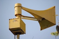
The Hurricane in Addyston, Ohio was likely removed sometime between 2001 and 2003, as it is still visible in the 2001 Hamilton County GIS imagery. The Federal 2001 that replaced it was not yet in place in 2001 either. Hamilton County GIS Imagery link: https://cagis.hamilton-co.org/cagisonline/
Hamilton County GIS Imagery from 2001 showing Addyston Hurricane:
Hamilton County GIS Imagery from 2001 showing Addyston Hurricane:
- 2001 Hamilton County GIS Imagery showing Hurricane.png (4.65 MiB) Viewed 28284 times
-
SpanishFriedEggs
- Registered User
- Posts: 143
- Joined: Tue Feb 20, 2024 2:14 am
- Real Name: John
- YouTube Username: SpanishFriedEggsOnYoutube
- Location: LCD soundsystem’s party
Re: ACA hurricane siren map (more locations + info needed)
Thanks for the information, I’ve just updated the information on that unit.Reedsiren1 wrote: ↑Mon Dec 30, 2024 2:14 amThe Hurricane in Addyston, Ohio was likely removed sometime between 2001 and 2003, as it is still visible in the 2001 Hamilton County GIS imagery. The Federal 2001 that replaced it was not yet in place in 2001 either. Hamilton County GIS Imagery link: https://cagis.hamilton-co.org/cagisonline/
Hamilton County GIS Imagery from 2001 showing Addyston Hurricane:
2001 Hamilton County GIS Imagery showing Hurricane.png
-
SpanishFriedEggs
- Registered User
- Posts: 143
- Joined: Tue Feb 20, 2024 2:14 am
- Real Name: John
- YouTube Username: SpanishFriedEggsOnYoutube
- Location: LCD soundsystem’s party
Re: ACA hurricane siren map (more locations needed)
Your welcome!Hamham8812 wrote: ↑Sun Dec 29, 2024 8:40 pmThank you so much for making this map. I have been looking for one that has been recently been updated for a bit.
-
Hamham8812
- Registered User
- Posts: 111
- Joined: Sun Dec 29, 2024 7:11 am
- Real Name: Felix
- Location: Taco Bell
Re: ACA hurricane siren map (more locations + info needed)
I found another image of the ACA hurricane prototype on historic aerials, that was in Florida to add to the map. And it only shows up in 1986.
- IMG_1053.jpeg (257.77 KiB) Viewed 27662 times
Owns a ex Trojan! federal signal model 7 And a 3-d printed ACA hurricane mkII and mini model 7T miscellaneous 3-d printed/lego sirens. Hopes for there to be a ACA hurricane 130 at sirencon one day.
-
Randomizer
- Registered User
- Posts: 77
- Joined: Sun Nov 28, 2021 6:01 am
Re: ACA hurricane siren map (more locations needed)
Where did you get the idea that Garland put in 612s? Garland supplanted and later replaced the Hurricanes with ATIs and, when par for the course those quit working, they were replaced with a system of Whelen Vortexes with VisuAlerts.Greenrid wrote: ↑Sun Dec 29, 2024 9:12 pmThe location for the Hurricane that was behind the church in Garland, TX was actually located here: 32.92119375393886, -96.68324438183394
If you look at this video of it, you can kind of tell that this is where it used to be before: https://www.youtube.com/watch?v=OvxbCEBzL2o
Although, it was replaced with an EOWS-612 when it was removed in 2004!
In fact, if you take 30 seconds and go to the coordinates you posted on Google Maps and then use Streetview and go back in time to 2008, you'll see an ATI HPSS-32 on what was obviously the Hurricane's pole (even going so far as to run the ATI's cabling through the Hurricane's blower pipe).
No offense, but how can you tell this is a Hurricane? Is there other info out there to suggest they had Hurricanes? It looks too blurry to tell what it was. And why would a Hurricane prototype only show up in the 80s (or better asked: when was the previous imagery from)?Hamham8812 wrote: ↑Tue Jan 07, 2025 3:04 amI found another image of the ACA hurricane prototype on historic aerials, that was in Florida to add to the map. And it only shows up in 1986.
-
Greenrid
- Registered User
- Posts: 338
- Joined: Sat Oct 14, 2023 4:32 pm
- Real Name: G______
- Location: Lansing, MI
Re: ACA hurricane siren map (more locations needed)
I never thought of checking the street view since the Hurricane was removed way before it became a thing. In one of the older aerial shots of the area after the Hurricane was removed, the ATI's shadow looked like an EOWS-612 (I'm writing this on my phone, so I can't show the picture).Randomizer wrote: ↑Tue Jan 07, 2025 7:11 pmWhere did you get the idea that Garland put in 612s? Garland supplanted and later replaced the Hurricanes with ATIs and, when par for the course those quit working, they were replaced with a system of Whelen Vortexes with VisuAlerts.Greenrid wrote: ↑Sun Dec 29, 2024 9:12 pmThe location for the Hurricane that was behind the church in Garland, TX was actually located here: 32.92119375393886, -96.68324438183394
If you look at this video of it, you can kind of tell that this is where it used to be before: https://www.youtube.com/watch?v=OvxbCEBzL2o
Although, it was replaced with an EOWS-612 when it was removed in 2004!
In fact, if you take 30 seconds and go to the coordinates you posted on Google Maps and then use Streetview and go back in time to 2008, you'll see an ATI HPSS-32 on what was obviously the Hurricane's pole (even going so far as to run the ATI's cabling through the Hurricane's blower pipe)
Sorry!
Proud owner of a E.A Labs Sireane Jr, a Uniden radio scanner, and a Sure-Lites emergency light!
Also the proud owner of the FULL 508 siren map! https://rb.gy/bgjrm1
I'm probably the go-to person to learn about my city's siren history.
Also the proud owner of the FULL 508 siren map! https://rb.gy/bgjrm1
I'm probably the go-to person to learn about my city's siren history.
Who is online
Users browsing this forum: No registered users and 14 guests